
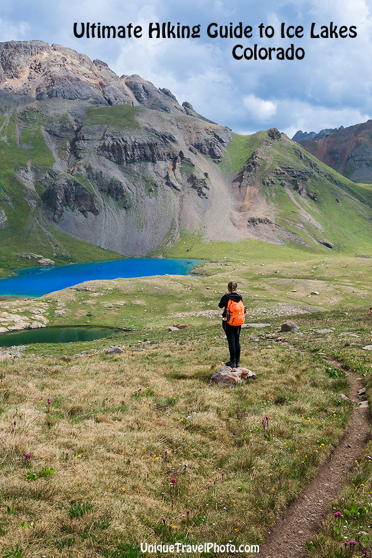
.jpg)

![]()
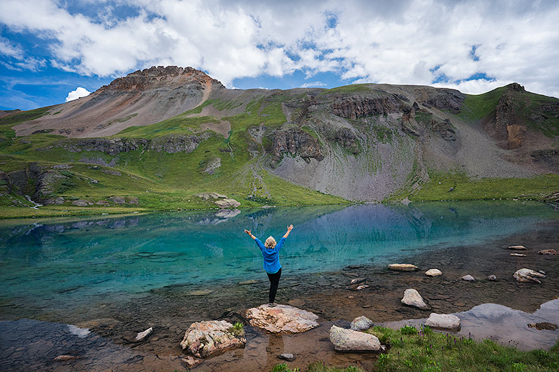
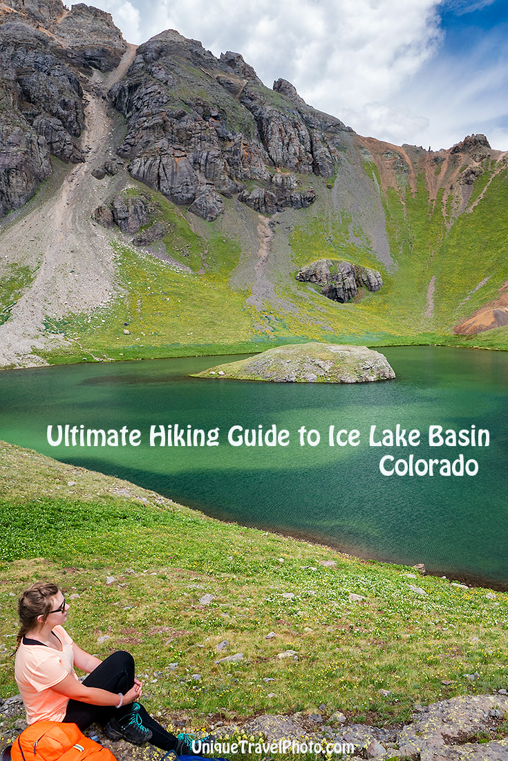
This hike is going viral. And no wonder. The lakes really are that stunning!
When I was researching this day hike, I found online trail information that turned out to be either misleading or lacking… so after hiking here this summer, I created a detailed hiking guide to Ice Lake Basin illustrating the text with lots of photos to help you plan your own journey to this amazing place that includes not only one lake, but 3 lakes!
Where? The magnificent Ice Lake Basin is near Silverton, an hour north of Durango, in the San Juan National Forest of southwestern Colorado. It has become the favorite, most popular day hike in the state for locals and tourists alike. But before you lace up your boots and dash outside, there’s a few things to know.
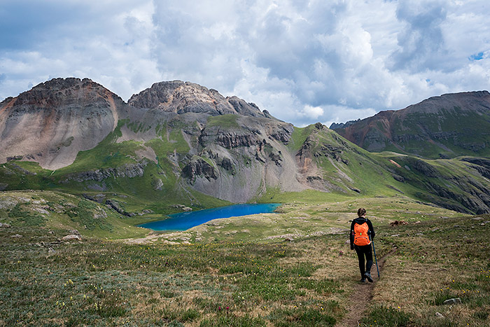
Hiking to Ice Lake from Fuller Lake
KNOW BEFORE YOU GO…
Challenging Terrain: Rated strenuous
The trail climbs steeply for the first 2 miles and then again the last mile to Ice Lake, with an elevation gain of 2,430 ft. The sign at the trailhead is a bit daunting. My daughter groaned when she saw the picture of two Empire State Buildings stacked on top of each other… yep, the equivalent of how high you’ll climb in a matter of hours. And if you continue on to Island Lake (why not!) prepare for a 2,550 ft gain.
Tricky bits include stream crossings— jumping across rocks, balancing on uneven logs or splashing through water, and facing your vertigo fears when hiking along the exposed rock face. There’s an even sketchier section on a sloped rock face with loose gravel on the trail extension to Island Lake. Also, know that snow often lingers into June, which can make wet rocks slippery.
Weather:
Thunderstorms are common in the mountains on summer afternoons, especially during July and August in the Ice Lakes Basin. Being struck by lightning is a serious danger at that elevation. Which is why most people hit the trail early in the morning so they are off the unprotected mountain before storms suddenly hit.
If you do get caught in lightning, throw aside anything with metal—like your backpack, thermos and hiking poles, and squat on a rock. Locals say you will feel it before you see the lightning strike, so if you feel the hairs on your arms and head being lifted, get ready! Weather can change quickly from hot to cold, calm to windy, dry to rainy or hail. Bring rain gear and warm layers, even gloves.
Altitude:
The trailhead begins at 9,840 ft at South Mineral Campground and climbs up to 12,270 ft. at Ice Lake, 12,390 ft. at Island Lake, and 12,609 ft. at Fuller Lake. That’s an elevation gain of nearly 3,000 feet! Altitude sickness can strike above 8,000 ft. High elevation can cause nausea, confusion, headaches and dehydration. So consider spending a couple days in Silverton (9,318 ft) to get acclimated first. And check out my tips for acclimatizing here.
Distance:
The hike will likely take longer than you expect. Plan on a 6-8 hour day. Leave before sunrise to avoid storms. Distance to Ice Lake in the upper basin is 8.1 miles round trip. (The trail guides that claim it’s a 2.6 mile hike actually stop at the meadow in Lower Ice Basin, but you came all this way to see the famous ice lake, and it’s in the Upper Lake Basin!) There are 2 other lakes to explore as well. If you hike to Island Lake add another mile, and Fuller Lake add another 1.6 miles. We hiked to all 3 lakes in the upper basin, and clocked in a little over 11 miles that day.
We hit the trail at 6am and returned at 3pm. Took us 3 hours to hike up to Ice Lake, and 2 hours down. The rest of the time was spent exploring the upper basin and hiking to the 2 other lakes.
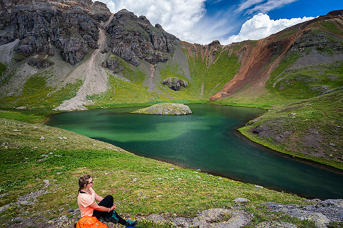
My daughter at Island Lake in the Upper Basin
Hiking guide to Ice Lake:
Trailhead
Directions: From Silverton’s Visitor Center, drive 2 miles north toward Ouray on Highway 550 (the Million Dollar Highway). After about 5 minutes, turn left on Forest Road 7 and continue straight ahead to the end of this flat gravel road (4.4 miles) to the parking lot for the South Mineral Campground, which takes about 10-15 minutes. Unless it’s a super busy day, there’s ample parking for all types of vehicles from passenger cars to RV’s.

Trailhead at South Mineral Campground
(SHORTCUT: You can shave off 500 ft elevation and a mile each way BUT the rutted road requires 4 wheel vehicles and only has room for 1-2 cars to park along the very steep and scary gravel switchback road heading up to Clear Lake. Then cross rickety boards from a washed out bridge at a rushing waterfall to access the spur trail. A man at the Visitor Center nonchalantly suggested we do this, but that is a mistake that should not be attempted in a rental, even if it’s a Jeep. There’s nowhere to turn if you want to—until a mile up where you’d park to access the spur trail. If you have your own 4×4 and driving rocky rutted roads are a breeze, then the zigzaggy shortcut is on the right-hand side of CR7 on the way to South Mineral Campground marked “Clear Lake.”)
The out and back trail to Ice Lake has 3 sections:
Forest
![]()
![]()
From the trailhead at South Mineral Campground, the clear hard-packed dirt trail wanders through a fir, aspen and cedar forest with numerous switchbacks that gradually climbs up, up, up. It crosses several tiny streams that are easy to cross by jumping across or stepping on rocks depending on the water level. After hiking a half-mile, or about 20 minutes up the trail, a larger stream requires you to shimmy across 2 uneven logs over Clear Creek. (Look to the right: the waterfall cascading down is where you’d cross on the shortcut spur above.)
Crossing Clear Creek
The forest provides shade most of the way. No signs are visible along the entire route, and sometimes spur trails may lead you astray. (Spur trails leading to waterfalls, old mining relics or homesteads rotting in the forest are better left to explore on the way down to avoid being caught on the mountain during thunderstorms). There is one fork toward the end of this section that veers right to Island Lake. Stay left to go to Ice Lake.
The hardest part of this 2.2 mile forested section is simply the ascent which feels more strenuous in thinner air.
![]()
![]()
Meadow
Ahhh… this mellow meadow section provides a much needed respite after all the climbing. You have reached the Lower Ice Lake Basin, and are now at 11,400 feet elevation. Take a deep breath and enjoy this beautiful trail, level and flat, that meanders through lush greenery bursting with wildflowers in July and early August.
hiking thru lupines and blue bells…
Flowers bloom in purple, pink, blue, white and yellow, from larkspur to blue bells, aspen daisies, Indian paintbrush and the state flower, Columbines.
![]()
![]()
The trail in the open meadow heads toward a rock face where you’ll cross a stream before you ascend.
![]()
![]()
At the end of this .9 mile section, there is some loose gravel in the path and another stream crossing where your boots might get a little wet. There are white rocks to jump across (but not enough if water levels are high).
![]()
![]()
Mountains loom in the distance with tall waterfalls spilling over cliffs from water emptying from upper basin lakes. The stream that snakes through the valley on the left as you hike is more visible as you ascend the rock face at the end of this section. Views of the meadow in the valley are spectacular from here.There is also a lake visible on a map but I never saw it in person. Maybe the vegetation was too dense? But even from atop the rocky ledge I couldn’t see a lake. Do you?
![]()
![]()
Rocky Ascent
Just when you’re tired…this last 1 mile stretch has another climb. Be careful here. The path is strewn with loose gravel and large rocks. Concentration is required for careful footing when the trail curves around an exposed rock face that is sloped toward the valley below. This unprotected section is the most dangerous part of the trail and especially risky when wet.
(On the return hike, leave early enough so you don’t get caught here in thunderstorms. But regardless of the weather, dry or wet, just go slow. Don’t hurry on the descent to appease people crowding behind you as this section tends to bottleneck. A hiker tripped and fell to his death here a week after our hike.)
After another switchback, the trail traverses up a long grassy slope and gradually curves left to the upper Ice Lake Basin…
![]()
![]()
…where you will finally see the vivid blue lake.
![]()
![]() Yay! You made it to Ice Lake!!
Yay! You made it to Ice Lake!!
Hiking Guide to Ice Lake, Fuller Lake and Island Lake in the Upper Lake Basin:
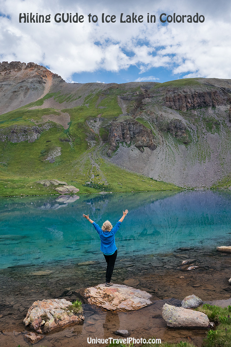
Ice Lake
This pretty alpine lake is nestled in a cirque of mountain peaks soaring above 13,000-ft. Depending on the sun, the water can vary from greenish turquoise to cobalt blue. When we arrived, there were just two couples and their dogs hanging around shore, and a couple emerging from the lone tent perched on a nearby knoll. Later that weekday morning, another 40 people had accumulated around the water. One brave soul even jumped into the glacial water for a chilly swim.
Chillin at Ice Lake
From here you have 2 options. Facing the lake, the most visible trail heading left from Ice Lake leads to Fuller Lake, and the faint trail etched in red sand to the right leads to Island Lake.
Good to know, because we went the wrong way, thanks to misleading information. Wanting to push forward to Island Lake before bad weather hit, I talked my daughter into continuing on before we stopped for breakfast/lunch/brunch. Following a trip report instructing hikers to head left from Ice Lake to Island Lake, we followed the clear visible trail up over grassy knolls…(not realizing we were headed the opposite way to Fuller Lake instead).
Fuller Lake
Distance is 1.6 mile round trip from Ice Lake. Elevation is 12,609 ft. Easy extension. Took us 45 minutes to hike each way including time to take pictures, plus a lunch stop = 2 hour diversion.
![]()
![]()
![]() Directions: walk south (left) from Ice Lake on the pleasant dirt path over gently rolling hills that passes a couple of ponds until you came to a small lake which does have several rocks in the middle of it. It looks nothing like the pictures of Island Lake—because it isn’t!
Directions: walk south (left) from Ice Lake on the pleasant dirt path over gently rolling hills that passes a couple of ponds until you came to a small lake which does have several rocks in the middle of it. It looks nothing like the pictures of Island Lake—because it isn’t!
![]()
![]()
Keep going. You’ll pass more ponds, and eventually arrive at a large lake. The end point will become obvious.
![]()
![]()
As you climb, look back behind you for an incredible view of Ice Lake and an unnamed pond.
![]()
![]()
![]()
We still didn’t realize we were going the wrong way. Perplexed, we kept hiking and looking for Island Lake. Finally, we ate our lunch on rocks overlooking yet another lake with a profusion of pink and purple wildflowers growing in the soggy shore.
Inhaling supplemental oxygen
A short stroll from here, we crested a hill and saw a large lake framed by red-tinged mountains at the end of the trail. It was pretty, but clearly not Island Lake.
![]()
Instead, we had arrived at Fuller Lake.
This is a popular place for hikers intent on bagging a “thirteener” as they can climb to the summit of Fuller peak at 13,761 ft. We did not see anyone attempting this, but the route follows around the right of the lake and heads up the orange-colored talus to the Fuller/Vermilion saddle, then turns left continues along the ridge to the summit, 13 miles RT. Those who bag such peaks usually camp up here to get an early start the next morning.
We explored the spongy shore of the lake for a bit, passing a picnic table and strewn metal from an old miner’s house. It was a scenic spot with reflections in the water and the peaks beyond of Fuller Peak, Vermillion Peak and Golden Horn. But since it took awhile to get here and time was limited, we turned around and headed back toward Ice Lake.
My favorite views of the day were those contrasting alpine lakes— one dark green, the other bright blue.
love, love, love these views!
Back at Ice Lake, we sat on a rock and pulled out our San Juan Mountain topo map. Better late than never!
![]()
![]() My daughter quickly noticed our error, and pointed out that Island Lake was the opposite direction. Sure enough, we spotted a faint trail crossing the mountain. Did we have time to hike there before the storms hit? That was our concern. We’d spent 2 hours on a wild goose chase looking for Island Lake…and now it was 11:30am. I didn’t know how long it would take to hike there. Skies were cloudy but still no rain or thunder. Who knew if we’d ever be back? Let’s go!!
My daughter quickly noticed our error, and pointed out that Island Lake was the opposite direction. Sure enough, we spotted a faint trail crossing the mountain. Did we have time to hike there before the storms hit? That was our concern. We’d spent 2 hours on a wild goose chase looking for Island Lake…and now it was 11:30am. I didn’t know how long it would take to hike there. Skies were cloudy but still no rain or thunder. Who knew if we’d ever be back? Let’s go!!
Hiking guide to Ice Lake and beyond… to Island Lake
Distance is 1.12 miles round trip from Ice Lake. Elevation is 12,432 ft. Moderate extension with one tricky spot. Took us 30 minutes to hike each way.
![]()
![]()
![]() Directions: from Ice Lake, head northeast (right) and cross the stream near the lake shore. Follow the dirt path climbing up around the mountain. Starts out easy…
Directions: from Ice Lake, head northeast (right) and cross the stream near the lake shore. Follow the dirt path climbing up around the mountain. Starts out easy…
![]()
![]()
But be careful scrambling over the rocks and loose scree on the exposed rock face where it’s easy to panic if you suffer from vertigo. Keep your eyes on the rocks underfoot and use hiking poles for balance as you make your way across this tailings pile, the scariest section of the day. There’s loose gravel, powdery talus and rocky boulders to maneuver on a steep slanted slope. A couple people who froze in panic had to be talked through the passage by their fellow hikers.
![]()
![]()
After you cross, take a moment to look back at the trail with Ice Lake shimmering in the distance.
![]()
![]()
After climbing ten more minutes, the trail dips into a basin where a stunning iridescent green lake hits you in the face. Bam! The distinctive rock in the middle of the water instantly recognizable. Yes, that’s Island Lake!!
![]()
This gem of a lake really dazzles in the sun!
Tucked into a cirque at the base of U.S. Grant Peak, the water gets its color from glacial residue deposited when snow melts into the lake. If you look closely at the reddish talus slope you can make out the faint trail where climbers trek to the top of the ridge. Zoom in with your telephoto lens and you might see people hiking waaaay up there. (There are 5 people hiking in the photo below–2 hiking the trail and 3 of them plus their dog walking along the ridge in front of the white cloud. Can you spot them?)
![]()
![]() Hikers on the ridge are on Grant Swamp Pass. Apparently this pass is part of the Hardrock Hundred Mile Endurance Run, this year at mile 15, meaning that the participants trek this very sketchy section at night using headlamps in the dark! (I cannot imagine.)
Hikers on the ridge are on Grant Swamp Pass. Apparently this pass is part of the Hardrock Hundred Mile Endurance Run, this year at mile 15, meaning that the participants trek this very sketchy section at night using headlamps in the dark! (I cannot imagine.)
I wanted to climb up the slope to the right to get a better vantage point of the entire lake (16mm lens wasn’t quite wide enough from shore). But we began hearing thunder rumbling in the distance after we arrived, and did not want to get stuck hiking the exposed rock face in the rain. So we spent a short 15 minutes at the lake before we headed back down the mountain, which took a total of 2.5 hours from Island Lake to our car.
After passing the sketchy part, I couldn’t resist snapping pics of the stunning scenery along the way. Loved the blueness of Ice Lake against all that green (85mm).
![]()
![]()
![]() We didn’t stop at Ice Lake, but kept hiking to beat others soon beginning their descent. A family behind us had young boys, and the Dad was telling them it was important to hike through the upcoming section before the rains hit. He was referring to the exposed rock face that had freaked out my daughter on the hike up. We let them pass us.
We didn’t stop at Ice Lake, but kept hiking to beat others soon beginning their descent. A family behind us had young boys, and the Dad was telling them it was important to hike through the upcoming section before the rains hit. He was referring to the exposed rock face that had freaked out my daughter on the hike up. We let them pass us.
As we continued down the rocky section there were several fit athletic types with numbered bibs running past us, clocking their time. They were training for the Hardrock Hundred Mile Endurance Run that was taking place in a couple days. Participants race over strenuous mountain terrain for 100 miles on a complicated trail connecting Silverton to Telluride, Ouray, Lake City and back to Silverton on a demanding course that climbs 33,992 feet. They were amazing to watch as they flew down the mountain past us. We stood in awe.
My daughter and I were also hiking Ice Lakes trails to train— preparing our bodies for high altitude hiking on an upcoming 5 day llama trek that would take place during their race. The elevation does take some getting used to.
![]()
![]()
We made it down and all the way through the forest before it began to rain. An epic day with views to match. Hiking to Ice Lake– I highly recommended!!
Add it to your bucket list. It’s that kind of place 😉
In fact, this hike now ranks among my favorite day hikes in the world (along with the WAVE, Tongariro Crossing, Tiger’s Nest & China’s Great Wall). What’s YOUR favorite day hike? I’d really like to know—I’m always looking for new places to explore, so let me know in the comments below!
Colorado state flower, Columbine
ADDITIONAL TIPS in hiking guide to Ice Lake Basin:
What to bring: lightweight waterproof/water resistant 33 L day pack (daughter used orange Alley-Pack, I used Hexin), waterproof topo map like San Juan Mountains Map, 1.5 liter water bottle or hydration bladder to zip inside your backpack, protein, snacks, hiking poles (we use this ultralight collapsible one by ZTOUR), rain jacket/pants/poncho (I love Marmot), fleece layer for warmth, gloves, sunscreen, bug deterrent, blister/first aid packs, hat, whistle, smartphone downloaded with San Juan National Forest app (learned of this afterward). Optional: wristband bug deterrent, portable O2 canister (shops sell them for $10-15 around Colorado), extra socks for wet stream crossings. Wear worn in hiking boots or trail running shoes that grip wet rocks. Flip-flops really are not appropriate, yet I saw several people heading UP the trail mid-afternoon (as we were coming down) wearing shorts and flip-flops without backpacks, warmer clothes or rain gear.
Photo gear: 16-35mm for landscapes, Lensbaby Sweet 50 for wildflowers, 85mm for compressing mountains, extra batteries, extra large ziplock (to store camera inside my camera bag during rain), lens rain cover (inexpensive solution works great). Wide angle (16-35mm) lens was my lens of choice for 80% of my pics. Necessary for capturing Island Lake in its entirety, and really 16mm wasn’t wide enough without climbing above and away from the lake. Use caution when stacking a polarizer on your lens at this elevation. Personally I didn’t use one, as they can cause the sky to go really dark and unnaturally blue because there’s more ultraviolet light at high altitude.
Photo tips: vary composition to capture hikers from a low angle, and the lakes from a high vantage point. Use a shallow depth of field for flowers (Lensbaby blurs the edges). Compress the mountains with a longer lens. Include people for scale and interest. Position the trails in the frame as leading lines. Try not to cut off the mountain tops when photographing the lakes to give a better sense of place.
~~~~~~~~~~~~~~~~~~~~~~~~~~~~~~~~~~~~~~~~~~~~~~~~~~~~~~~~~~~~~~~~~~~~~~~~~~~~~~~~~~~~~~~~~~~~~~~~~~~~~~~~~~~~~~~~~~~~~~~
Save this post for later Pinterest fans! Pick your favorite pic to pin on your own travel board.
![]()
![]()
![]()
![]()
![]()
Kristen - Thank you so much for the expensive guide. This was the most in depth one I found, super helpful.
Kim - Thanks so much, Kristen! Hope you enjoy the hike as much as we did. 🙂
Kevin Conley - Thanks for the great detail, extremely helpful. My favorite day hike is the Narrows in Zion NP, thanks for sharing you favorites, love to compare and line up the next challenge.
summer groteluschen - Was it easy to navigate where you were going? I know you said you made one error, but was the rest of the trip pretty easy to navigate? You mentioned a map, where did you get this map for the hike? Let me know, thanks.
Kim - Thanks, Kevin. I’ve had my eye on the Narrows too…and yes, it’s fun to line up the next challenge!
Kim - We used the San Juan Mountain topo map which we purchased in Silverton at the outdoor adventure store (I don’t recall the exact name, but there was only one such store along the 3 blocks on main street.) I think the newest version is this: Telluride, Silverton, Ouray, Lake City (National Geographic Trails Illustrated Map (141)) Map – Folded Map, January 1, 2019 (available on Amazon). I’d say the main route to Ice Lake is easy to navigate, especially since you will likely see many other hikers along the way. The 2 other lakes are a bit trickier thus my attempt to specify all the details in the post.
Anne - Hello!This was a fantastic read! I will be in Telluride and am interested in doing this hike. My group will have 2 older individuals, 65, 68 and 2 kids, 8 and 11 …. would this trail be suitable for those ages? You mentioned a rocky ascent that was open and unprotected so that has me concerned. For reference … I have done hikes in Tahoe and the Smoky Mountains with the same group of hikers. Thank you in advance!
Kim - Hi Anne, thanks for reading! Concerning the ages of hikers in your group, I can only advise that mobility, stability, balance control and distractability are far more important safety factors than age. The one open section ascending toward Ice Lake didn’t look risky at all to me going up, just coming down. I think people are prone to tripping when rushing down, trying to get off the mountain before lightning strikes and that area gets bottlenecked with everyone coming down at once. The far tricker section that I personally would avoid with kiddos (even my 18 yr old was freaking out here) is the open faced, rocky landslide-like trail leading to Island Lake. Altitude also factors in to this hike as dizziness can lead to confusion and unsafe stepping. I certainly don’t want to discourage you from this beautiful hike–it remains one of my favorites–just want people to know what to realistically expect and be safe!